- Keep Cool
- Posts
- Growing the constellation
Growing the constellation
How Orbital Sidekick plans to track methane gas from space.
Nick van Osdol
September 07, 2023
What if we could see greenhouse gases with the naked eye? Perhaps, like plastic piling up on an otherwise pristine beach, it would bother us more. Viscerally.
What if CO2 looked yellow, methane looked green, and nitrous oxide looked red? Perhaps seeing these gasses every day would make them less of an abstraction. Perhaps it would give us a more immediate appreciation for their sources and how those relate to everyday activities across society.
Take methane, for instance. Methane drives anywhere from 20 to 30% of observable global warming. When you hear me harping on whether climate tech remains too myopically focused on carbon, this is one of the points whirring in the back of my mind.
If we could see methane with our naked eyes, it would unlock very practical applications; oil and gas and other energy companies recognize that eliminating methane leaks from their operations constitutes ‘lowish’-hanging fruit to clean their act up a bit and a PR opportunity. And, good news! While we can’t see methane, there are tech solutions that make spotting it possible.
Clearing the air with hyperspectral satellites
Orbital Sidekick's mission is to make methane, as well as many other things that are hard or impossible for the naked human eye to see, visible.
When I sat down with CEO Dan Katz, he described the goal as being able to
…fingerprint anything on earth with hyperspectral satellites.
Orbital Sidekick is building a spectral intelligence platform. On the hardware side, this involves launching hyperspectral satellites into space. As of this writing, the company has deployed three satellites, and its roadmap is keenly focused on "growing the constellation."
So. What is a hyperspectral satellite? Everything on Earth, whether a plant, metal ore in the earth, or a gas reflects and absorbs light in a unique manner. While methane isn't visible to the naked eye, it does absorb and reflect light in the infrared light region (as opposed to the visible light region). A high spectral resolution includes 500 hundred colorbands across the infrared light region instead of the three data points – red, green, and blue – your iPhone camera ingests. As a result, armed with a high spectral resolution, you can 'see' methane gasses.
The satellites Orbital Sidekick launches can provide the high spectral resolutions necessary to spot methane. Traditionally, this type of information has been used in mineral exploration, as it can help look for known alteration minerals on the Earth's surface that can indicate where there's nickel or cobalt deposits in a given region. It’s also been used for defense applications. But it hasn’t been scaled commercially.
Orbital Sidekick's go-to-market strategy is explicitly focused on methane, however. Specifically, they want to help oil & gas companies monitor their pipelines and other infrastructure for leak prevention and detection. This makes sense as a beachhead market, given:
Oil & gas companies are reaping record profits and make good customers
There's an economic incentive – i.e., not wasting gas – to prevent leaks
There's 'top-down,' policy pressure to clean up methane leaks
There's 'bottom's-up' interest: O&G gas companies want to notch climate 'wins'
While oil & gas infrastructure isn't the main source of methane emissions globally (enteric fermentation and agriculture in general are), their contributions are still significant:
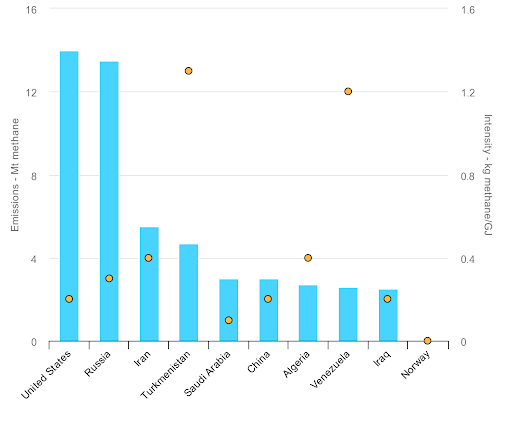
Total methane emissions (blue bars) as well as relative intensity of methane emissions (yellow dots) from oil and gas operations across various countries. (via IEA)
Oil and gas companies, at least in developed countries (sorry, Turkmenistan), are already incentivized and pressured to mitigate methane leaks and fugitive emissions. Incentives come in the form of realizing more economic value. Methane is basically natural gas. Leaking less methane while identifying flaws in infrastructure, makes good financial sense.

Data: S&P Global Commodity Insights; Chart: Axios
Then there are regulatory and shareholder pressures, too. On that front, here are some notes:
The Inflation Reduction Act includes incentives for methane mitigation and paves the path to establish a tax on oil and gas methane emissions.
In 2021, Canada unveiled a target to reduce methane emissions from the oil and gas sector by at least 75% from 2012 levels by 2030.
In 2022, Nigeria released guidelines to reduce fugitive methane emissions by 60% by 2031.
By 2030, there may well be even more robust legislation in place that forces oil & gas companies to act more aggressively on eliminating methane leaks from their operations.
Beyond the hardware, Orbital Sidekick recognizes the opportunity inherent to making a once prohibitively expensive data stream accessible. In our conversation, Dan noted that satellite launch costs have fallen from roughly $20,000 or $30,000 to $5,000 per kg for satellite launches.
And the availability of launches has also increased significantly. Without beating the AI drum too hard, the less discussed leverage point amidst the AI craze isn’t the cost or power of computation. It’s what happens when you have fundamentally new data to feed into models.
While Orbital Sidekick is starting with leak detection, Orbital Sidekick envisions a world where enough reps at analyzing their imagery allow them to move to a paradigm of prediction and prevention concerning oil & gas companies’ infrastructure assets.
That may be years down the roadmap. But ideally, once you’ve spotted enough methane leaks in, say, pipelines, there are discernible signals in hyperspectral imagery that can signal and help spot leaks before they happen.
Further, as we’ll discuss a bit more later on, Orbital Sidekick sees a future where it can expand its business to leverage several other use cases for its hyperspectral data, including mineral exploration, precision agriculture, and more.
What’s the catch?
At this stage, you may be asking yourself, “What’s the catch?”
Dan noted that Orbital Sidekick’s long-term goal is to monitor every single mile of pipeline worldwide.
Building out the constellation of satellites and the rest of the hardware and software stack that would support this vision is, of course, no small feat. It involves launching satellites! While less expensive today than decades ago, it is still costly. This is a high CAPEX business, any way you slice it.
Orbital Sidekick has raised $46.8M across three funding rounds to launch three satellites so far. To launch more, they’ll need to continue to raise funds, manage burn, and secure significant paying customers.
Nor are they the only company that wants to build a constellation of hyperspectral satellites. SatSure, based out of Bengaluru, India, announced it raised $15M in Series A funding this week for its satellite Earth observation data analytics business. The company aims to launch four high-resolution optical and multispectral satellites by Q4 2025.

Methane gas plumes, as captured by Orbital Sidekick’s hyperspectral satellites (courtesy of the company)
Similarly, while the data opportunities with hyperspectral imagery are significant, plenty of progress still needs to be made in parsing the imagery and ensuring the fidelity of its results. Especially as Orbital Sidekick considers expanding to other verticals, say, biomass and carbon quantification for nature-based carbon sequestration projects, deciphering what’s what in a dense forest ecosystem is complex. In many cases, hyperspectral imagery will complement other data sources, whether hand-held tree calipers or drones.
That’s also part of the appeal here, however. The constellation of hyperspectral satellites that would make mapping every mile of oil and gas pipelines globally possible would open up other applications to aid in monitoring and successfully deploying other clean energy infrastructure.
For instance, it could help utilities monitor vegetation on and around transmission lines, a challenge that has caused serious problems (e.g., the Dixie wildfire in California) in the past. It could help companies navigate the complicated work of securing the right of ways for pipelines, transmission lines, and other infrastructure. It could help insurance companies with fire and flood risk mapping and monitoring. And, looping back to traditional hyperspectral applications and a point touched on earlier, there are opportunities to accelerate critical mineral discovery with hyperspectral imagery.
The net-net
Zooming out, Orbital Sidekick’s hardware slots in nicely in a growing suite of ‘climate tech data layer’ solutions. The value of this data layer will ideally grow exponentially as each individual component of the hardware stack improves and as other software solutions harmonize disparate data streams.
What’s the climate tech data layer? Countless technologies across countless vantage points:
Companies like Aerones use drones and other robotics to monitor energy infrastructure like wind turbines.
Advances in technologies like LiDAR (often equipped on drones) make it possible to create detailed 3D maps of infrastructure, improving inspection and accelerating issue identification.
Better thermal imaging solutions make spotting heat anomalies (which portend potential problems) in transmission or pipelines easier, too.
And technologies like Yard Stick’s hand-held soil probes, improve more granular, on-the-ground data points.
When you combine the confluence of these new technologies with exponential improvements in compute and data processing (in other words, AI), it’s hard not to be cautiously optimistic. Harmonizing the data from all these disparate sources into cohesive models could unblock many potential business opportunities, ranging from carbon markets to methane mitigation to mining.
For entrepreneurs, a question to ask yourself (and which I’ll end on) is what business would you want to be in if you assume the quality of data from hyperspectral satellites, or any other component of the climate tech data layer, continues to improve and its cost continues to trend down over time.
Reply